Source – gizadeathstar.com
- “…How might this tie in to HAARP? – Very easily: HAARP is an ionospheric heater. That is to say, its phased antennae arrays are designed so load energy into the ionosphere, and can do so quite literally with pinpoint accuracy….note that the Gakona-HAARP Notice to Airmen was issued on June 17th, and the heat wave alert article is updated for June 27″…I suspect we’re looking at yet more evidence of a covert war taking place”
SM:….A key element in the ongoing “Strategy of Tension’ is the ability to create the full scale illusion that “the Sky is Falling’…adverse weather engineering coupled with the controlled media narrative surrounding COVID functions to maintain unsuspecting target populations in a state of learned helplessness & fear – the very core principles & applications of the ‘Black Arts’ in covert hybrid warfare…
HEAT WAVES AND HAARP – By Joseph P. Farrell
My email inbox was so stuffed this past week that it was very difficult to decide what to blog about. Indeed, I’ve already done one blog this week on two different articles submitted by two different people, because I thought those articles might have been related.
Today is the same: we have two different articles submitted by two different people that might be related, and in my “high octane speculation methodology” I am going to assume that they are.
(Also Read: Literally hotter than the Sahara: How Western Canada became one of the hottest corners of the globe @ https://nationalpost.com/news/canada/literally-hotter-than-the-sahara-how-western-canada-became-one-of-the-hottest-corners-of-the-globe)
Firstly, we have the following article submitted by S.D. about a NOTAM (Notice to Airmen) recently issued by the Federal Aviation Administration (FAA):
Is HAARP Firing Up? FAA Issues Warning About “Electromagnetic Radiation”
There’s a lot going on here, but note especially the following:
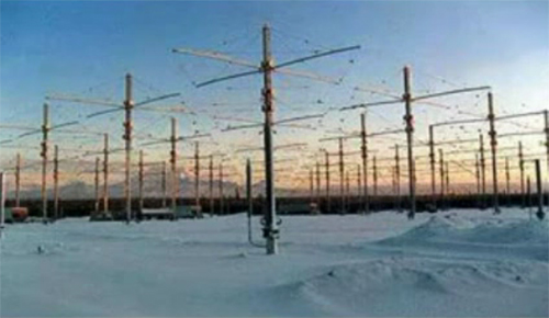
A longstanding topic of great speculation among curious minds is HAARP, a controversial Alaska-based research facility that studies the outermost layer of Earth’s atmosphere: the ionosphere.
HAARP (short for High-Frequency Active Auroral Research Program) has been at the center of wild speculation that its high-power radio frequency transmitter facility can control the weather. Though those claims have yet to be confirmed, conspiracy theorists say otherwise.
(Also Read: HAARP, the most powerful ionosphere heater on Earth @ https://physicstoday.scitation.org/doi/10.1063/PT.3.3032)
Before we go further, let’s stop right there and note a few things. The basic patents for HAARP were taken out by Bernard Eastland in the 1980s, and many think that it was a component of President Reagan’s Strategic Defensive Initiative (SDI), or as it was more popularly known, “Star Wars”. When those patents are actually read, two things are mentioned as possible applications for such a large ionospheric heater: missile defense, and weather modification. There’s no if’s, and’s, or but’s about it. (One can read these patents in Dr. Nick Begich’s and Jean Manning’s book, Angels Don’t Play this HAARP).
With that in mind, now consider this:
HAARP has fallen out of the news cycle in recent years for inactivity, but there’s reason to believe that it’s being fired back up for “scientific research.”
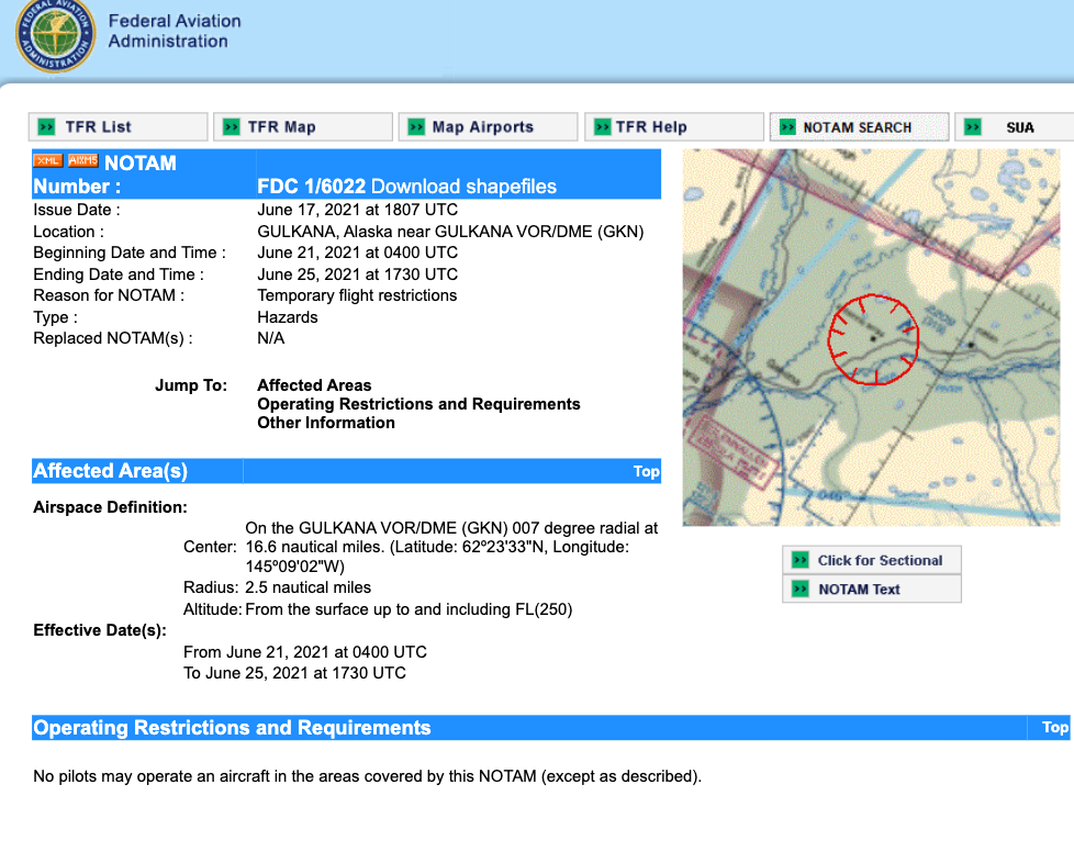
A notice to airmen (known as a NOTAM) was issued by the Federal Aviation Administration on June 17 with the beginning date of June 21 through June 25.
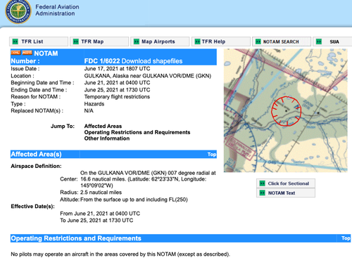
The NOTAM places “temporary flight restrictions” around Gulkana, Alaska, where the HAARP facility is located. It reads that planes are restricted from flying in the Gulkana airspace due to “electromagnetic radiation for scientific research.”
FDC 1/6022 ZAN AK..AIRSPACE GULKANA, AK..TEMPORARY FLIGHT RESTRICTIONS WI AN AREA DEFINED AS 2.5NM RADIUS OF 622333N1450902W (GKN007016.6) SFC-FL250 FOR ELECTROMAGNETIC RADIATION FR SCIENTIFIC RESEARCH. PURSUANT TO 14 CFR SECTION 91.137 (A)(1) TEMPORARY FLIGHT RESTRICTIONS ARE IN EFFECT. TRANSIT THRU THE AIRSPACE MAY BE AUTH BY HAARP COMMAND CENTER, TEL 907-822-5497 OR FREQ 123.3. ANCHORAGE /ZAN/ ARTCC TEL 907-269-1103 IS THE FAA CDN FACILITY. DLY 0400-1730 2106210400-2106251730.
So there you have it: the FAA has placed a restriction on the airspace around Gakona, Alaska, the actual home of HAARP, indicating that there will be unusual electromagnetic radiation in the area. (While we’re at it, let’s recall those bird deaths I mentioned earlier this week: might this have something to do with them? Given the strange behaviour of birds attacking 5G towers, I wouldn’t rule it out, but time will tell.)
Now consider the following article submitted by K.M.:
‘Life-threatening’ heat wave begins in the Northwest
Now note that the Gakona-HAARP Notice to Airmen was issued on June 17th, and the heat wave alert article is updated for June 27. According to that article, a record heat wave is expected to hit the American northwest:
A historic and “life-threatening” heat wave is underway across the Pacific Northwest, the likes of which — in terms of high temperatures and duration — has never been experienced before in that part of the country. AccuWeather forecasters are calling for record-shattering heat to linger through early week, not only making life miserable for a part of the country where air conditioning is not prevalent but also posing a significant health risk to millions.
Consecutive days of high temperatures well into the triple digits are forecast throughout parts of Oregon and Washington, which includes the Interstate 5 corridor. Both Portland, Oregon, which could see the mercury crack the 110-degree-Fahrenheit mark, and Seattle, which is expected to top 100, will see temperatures soar 30 to 40 degrees above normal. Points farther inland are likely to have temperatures balloon to above 115.
Average highs in June can be anywhere from the 70s in eastern Washington and Oregon to the 80s in western areas and into Idaho.
The dangerous heat is forecast to peak through Monday as high pressure settles in and enables temperatures to climb to new heights. (Boldface emphasis added)
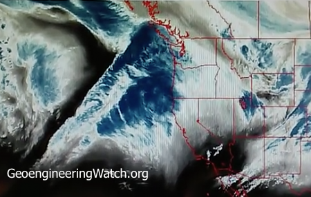
To this is appended the following picture, showing the area of high pressure in the northwest, and the corresponding area of low pressure over the central plains region of the country:

So how might this tie in to HAARP?
Very easily: HAARP is an ionospheric heater. That is to say, its phased antennae arrays are designed so load energy into the ionosphere, and can do so quite literally with pinpoint accuracy. Loading massive amounts of energy in such a fashion can raise the ionosphere, creating regions of low pressure, which in turn can lower it elsewhere, creating regions of high pressure, with corresponding shifts in the jet stream, all of which is visible on Accuweather’s map. (Think of the Chinese flooding of last year and this year in connection with this.)
So in my opinion, we’re looking at weather modification here.
The question is, why would anyone want to bake the northwest, or inundate the lower plains?
This is a case of “you tell me”, but for my part, I suspect we’re looking at yet more evidence of a covert war taking place. The question is, against whom? And yes, I do think that Chinese defector story might be related to all this…
See you on the slip side…
Related….
NASA Satellite Imagery Reveals Shocking Proof Of Climate Engineering
January 16, 2019
Dane Wigington
geoengineeringwatch.org
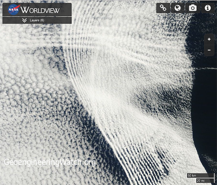
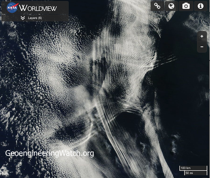
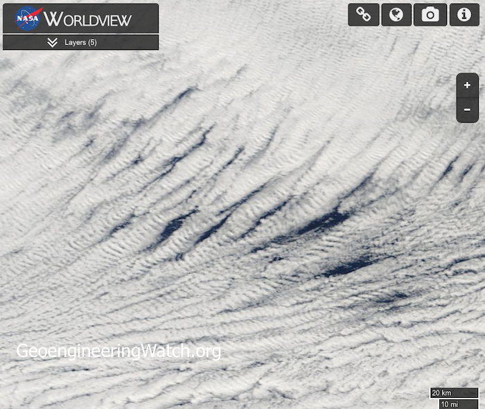
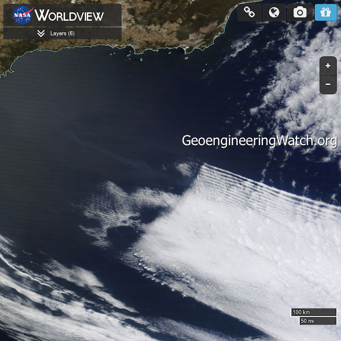
In regard to difficult to accept and unpleasant truths, a picture is worth a thousand words. The photo images shown below were captured from NASA satellite sources, they are truly alarming. These images provide shocking and undeniable proof of the ongoing global climate engineering/geoengineering/solar radiation management assault on our planet and its life support systems. Highly toxic heavy metals and chemicals that are systematically sprayed into our atmosphere from jet aircraft as part of the geoengineering / solar radiation management (SRM) programs, are manipulated with extremely powerful radio frequency signals. These signals are transmitted from countless locations around the globe from various types of transmission platforms (ionosphere heater installations like HAARP, SBX radar, NEXRAD, etc.). The impact of the microwave transmissions on cloud formations is profound and highly visible (square cloud formations are created under some scenarios).
In the series of NASA satellite images below, many variances of radio frequency cloud impacts can be observed. The degree to which the ongoing climate engineering/climate/intervention/weather warfare is disrupting Earth’s atmosphere and life support systems is already beyond catastrophic and rapidly escalating all over the globe.
Click to enlarge any of the images below
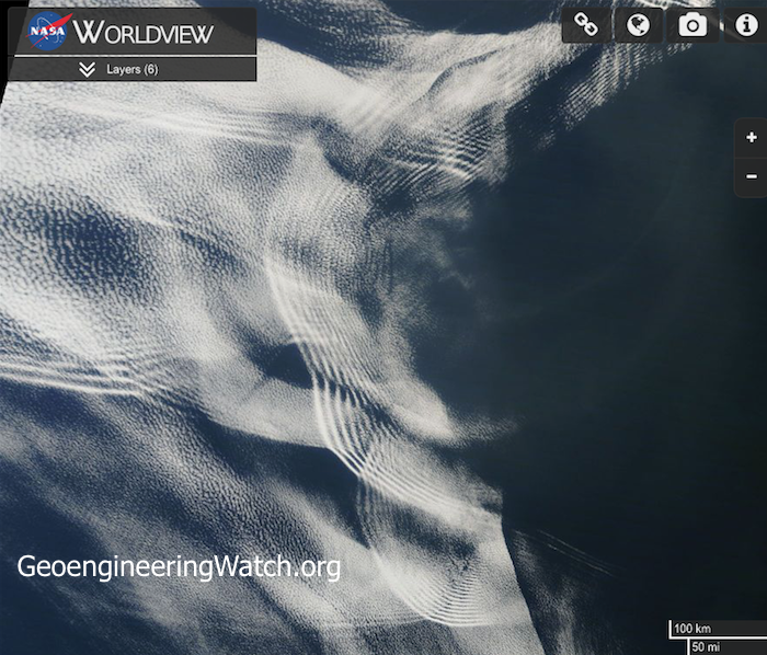
Off of east coast of Australia
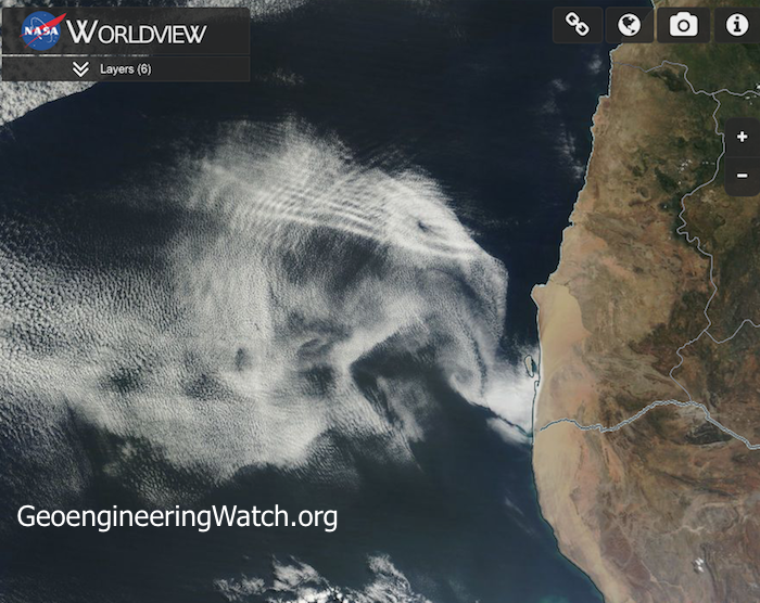
West coast of Africa
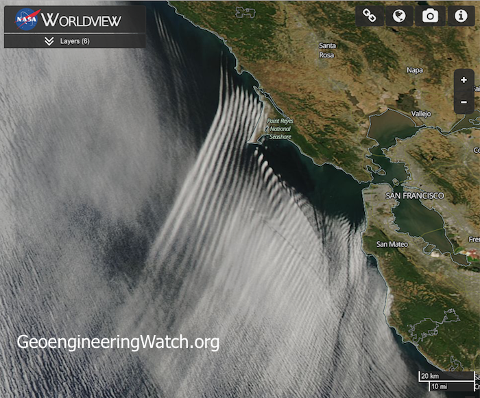
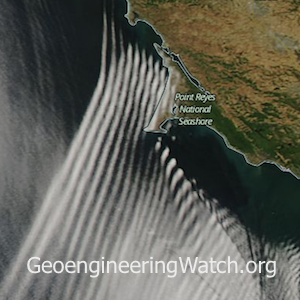
California coast
Off of Africa’s west coast
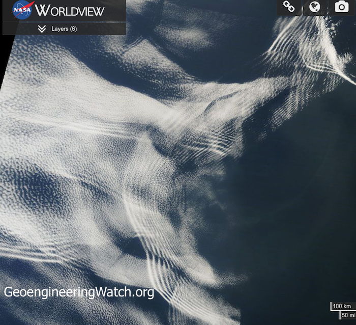
Off of Africa’s west coast
Off of Africa’s west coast
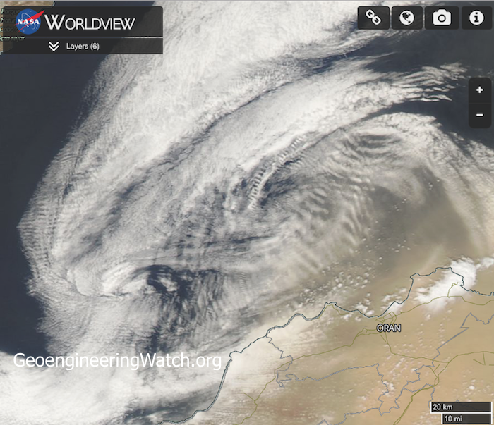
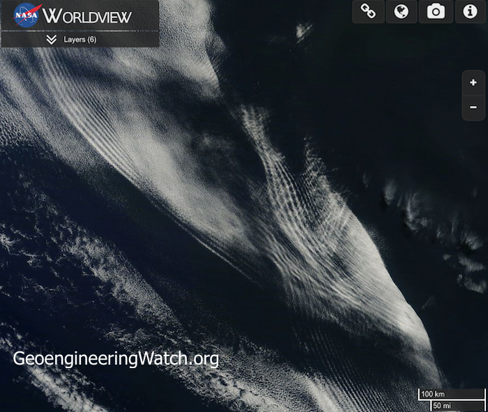
South of Spain in the Alboran Sea
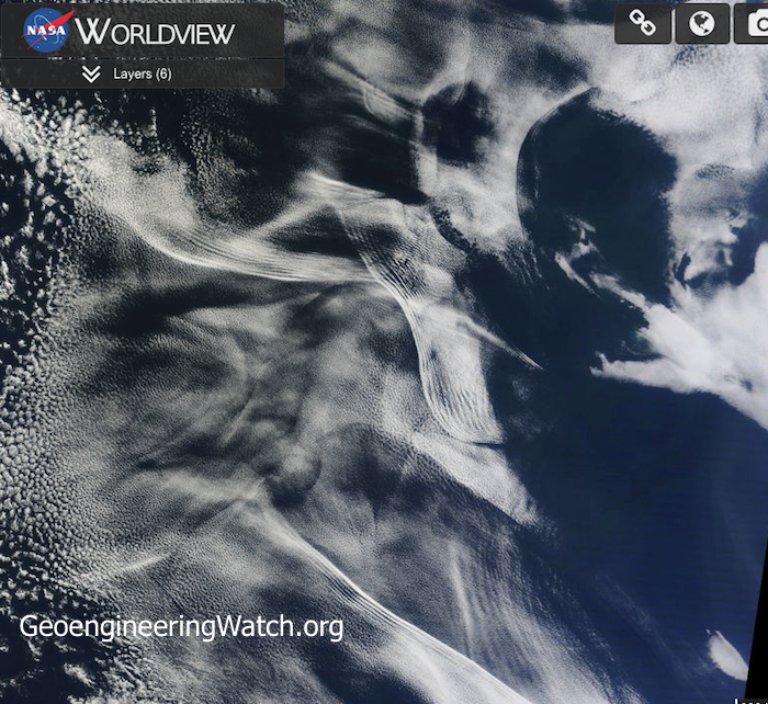
Off of Africa’s west coast
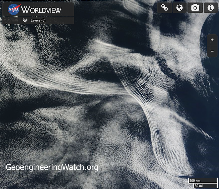
Off of Africa’s west coast
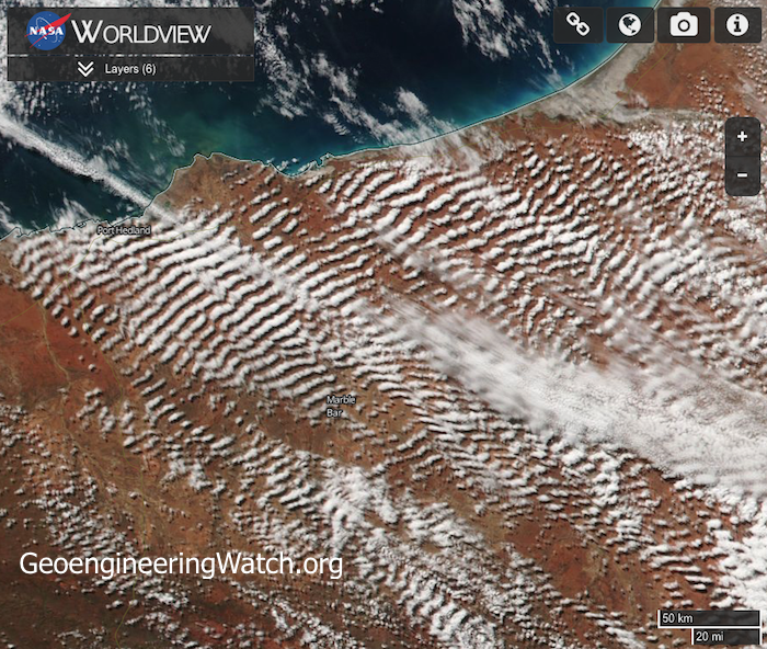
The northwest coast of Australia
Off of Africa’s west coast
Off of Africa’s west coast
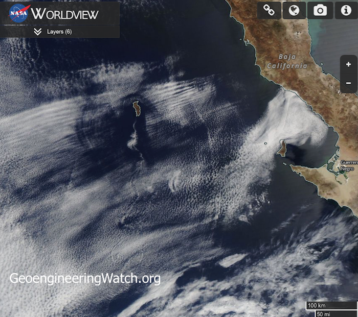
Eastern Pacific ocean west of Baja California
The Southern Ocean near Antarctica
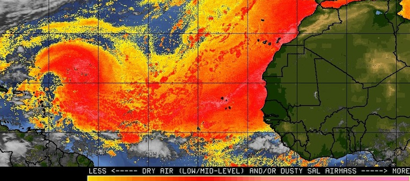
Hurricane suppression/manipulation is one aspect/agenda of the climate engineers. 85% of the hurricanes that impact the US originate from Africa. Low pressure systems migrate toward the west, off of Africa’s coast. A great deal of climate engineering/intervention takes place in this region, thus a number of the satellite images shown in this post were captured there. In the attempt to mask the climate intervention activity, the cyclone suppression occurring off the coast of Africa is officially blamed on “dust”. Of course there is no acknowledgement of the ongoing climate engineering atrocities. The quote below is an excerpt from a FOX news article.
Right now, much of the Gulf of Mexico and parts of the Caribbean have slightly warmer than normal ocean temperatures which would normally aid in tropical development. But there is so much dust and dry air in the atmosphere that storms are getting choked off before they even get started.
Though some may feel that cyclone suppression is beneficial, such interference with Earth’s natural rhythms and systems has a long list of catastrophic downstream effects. Available data indicates that in other scenarios the climate engineers are actually augmenting and steering cyclones to serve their own agenda. “Hurricane Matthew” may be an example of weather warfare on an unimaginable scale. Is hurricane Matthew being heavily manipulated and steered by the climate engineers? The evidence continues to stack up. Below is a satellite photo clearly showing atmospheric “waves” surrounding hurricane Matthew. SpaceWeather.com has labeled these as “gravity waves”, but is that what these visible “waves” actually are? No. The satellite photos already shown in this post inarguably reveal heavy atmospheric manipulation from extremely powerful radio frequency/microwave transmissions and atmospheric aerosols. These transmissions leave a signature pattern on high level cloud formations that are saturated with electrically conductive heavy metal nanoparticles which are dispersed from jet aircraft as part of the ongoing climate engineering insanity.
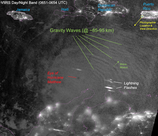
Does the photo above really show “gravity waves” surrounding hurricane Matthew? Or does it show the signature pattern of extremely powerful radio frequency/microwave transmissions interacting with aircraft dispersed atmospheric aerosols? The latter is the case, both of these elements / factors are a core part of climate and storm manipulation and steering. Photo: SpaceWeather.com
For those that want to examine the most complete climate engineering presentation from Geoengineering Watch, view the video below.
The global power structure long ago made the choice to subject our planet (and the entire web of life that it supports, including the human race) to an unimaginably massive and destructive climate intervention/weather warfare assault. This decision was made without the knowledge or consent of global populations. If we stand by and allow the decimation from the climate engineering insanity to continue, very soon Earth’s life support systems will be beyond any recovery. This is not speculation, but a mathematical certainty. Help us with the most critical battle to expose and halt the climate intervention/weather warfare assault, all of us are needed in this fight. Sharing credible data from a credible source is key, make your voice heard.
DW
May be freely reprinted, so long as the text is unaltered, all hyperlinks are left intact, and credit for the article is prominently given to geoengineeringwatch.org and the article’s author with a hyperlink back to the original story.Read More
Geoengineering Microwave Transmissions And Their Connection To Hurricane Florence
September 19, 2018 54 Comments


Share3.8KTweet+1SharePin63.8K Shares
Dane Wigington
GeoengineeringWatch.org
Every aspect of our weather is being altered and manipulated by geoengineering programs, including hurricanes / cyclones. Radio frequency / microwave transmission installations have been and are a core component of the ongoing global climate engineering operations. The 2+ minute video below tracks the path of Hurricane Florence while clearly revealing the network of radio frequency / microwave transmission facilities that were used to manipulate and steer this storm.
Like Hurricane Florence, Hurricane Harvey (2017) was heavily manipulated, radio frequency / microwave transmissions were a core aspect of that manipulation. Hurricane Maria (2017) and Jose (2017), the same. Microwave transmission facilities are undeniably being used to manipulate climate and weather systems. The agendas behind the climate engineering programs are many and multilayered. Climate engineering / weather warfare operations are wreaking havoc with the Earth’s remaining life support systems. What will it take to wake the masses to what is occurring in the skies over their heads? Exposing and halting the climate engineering assault is the great imperative. All of us are needed to bring these programs to light and to a halt. Share credible data from a credible source, make your voice heard.
DW
May be freely reprinted, so long as the text is unaltered, all hyperlinks are left intact, and credit for the article is prominently given to GeoengineeringWatch.org and the article’s author with a hyperlink back to the original story.Read More
Geoengineered Western US Meltdown To Cool The Rest Of The Country, Again
August 1, 2017 165 Comments

Share4.6KTweet+1SharePin164.6K Shares
Dane Wigington
GeoengineeringWatch.org
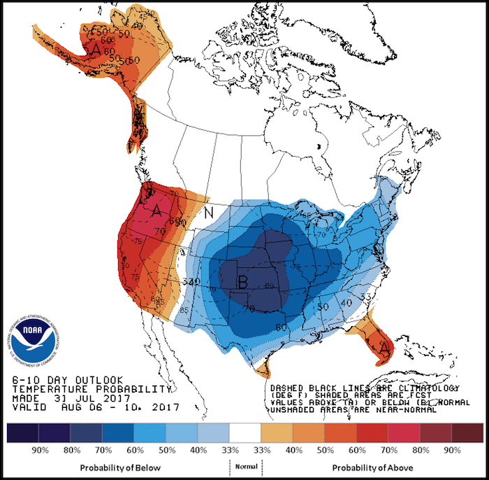
The Western US has, at minimum, long since become a climate sacrifice zone for the geoengineers. The current NOAA departure from normal high temperature “forecast” map is below. This map reflects nothing less than the “scheduled” weather from primary climate engineering contractor, Raytheon, who does all the forecast modeling for the National Weather Service (NWS) and the National Oceanic and Atmospheric Administration (NOAA). In this completely engineered scenario, ionosphere heater induced record shattering heat will bake the Western US while potential record cool temperatures may occur in the Central US. The scenario shown below has been repeated by the climate engineers countless times since 2007.
The HAARP ionosphere heater installation in Alaska is only one of many large radio frequency / microwave transmitters located around the world that are utilized for climate engineering purposes.

When the ionosphere is bombarded with the massively powerful RF / microwave transmissions from installations like HAARP, high pressure heat domes can be created and maintained. In the case of the current record shattering high pressure heat dome over the US West, the clockwise spin of upper level air currents around the high pressure zone allow the weather makers to steer cooler air from the Pacific into the center of the country while completely bypassing the West.

Though the “official” forecasted record highs in the West are alarming enough, the actual temperature readings on the ground are now significantly higher than the “official” readings in almost all locations monitored by GeoengineeringWatch.org and others.

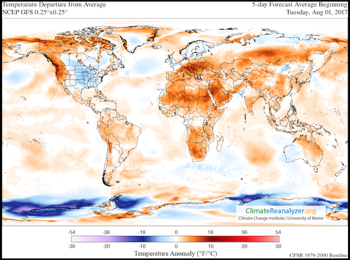
The latest “Temperature Departure From Average” map shown below is very revealing in regard to the true state of global temperatures. Where is it cool? Where not? The coming climate engineering cool-down in the eastern two thirds of the North American continent truly stands out. Antarctica also stands out as a focus of the global climate engineering assault, a primary element of which involves chemical ice nucleation for weather modification. Due to the recent collapse of the immense Larsen C ice shelf in Antarctica, the climate engineers appear to be fully engaged in an increasingly desperate and destructive attempt at damage control in the polar regions.
The increasingly radical swings in Greenland melt extent is another glaring red flag in regard to the on and off engineered cool-downs which include chemical ice nucleation as a major factor. The extreme fluctuations in the Greenland surface melt graph below are alarming and indicative of the ongoing climate engineering assaults in the region.

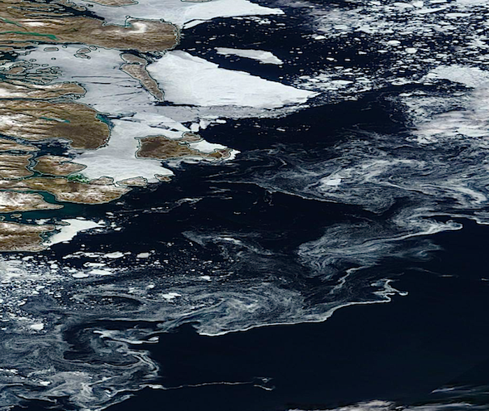
Sea surface chemical ice nucleation processes are also being utilized on a massive scale. The swirling patterns left from chemical ice nucleation materials on the sea surface are very clearly visible in the NASA satellite image below (east coast of Greenland). Such patterns are also clearly different from the usual broken ice mosaic seen in the upper right of the satellite image.
The power of chemical ice nucleation elements must be seen to be believed, the lab test shown in the 15 second video below gives a glimpse.
Arctic ice mass (volume) has dropped precipitously in recent decades and is now at dangerously low levels. In the attempt to hide this fact from the public for as long as possible, the climate engineers have decimated the planet and the atmosphere as a whole.

The very short animation in the video below is even more revealing in regard to the true state of the Arctic ice volume implosion.
Where are the US temperatures predicted (scheduled) to go in the coming months? The NOAA long term forecast map below reveal the accelerating warming that will soon become impossible to deny for even the most willfully blind.

Again, the record heat / record cool weather whiplash scenarios (that has now become the norm in the US and the world) is completely engineered, completely unnatural, and until the recent past, meteorologically unprecedented. Why would the climate engineers carry out such scenarios? Because engineered cool-downs (like the one currently slated for the eastern two thirds of the country) continue to fuel the division and confusion in the population as to the true extent of damage to the climate system (which global geoengineering is making exponentially worse overall while simultaniously destroying the ozone layer). The climate engineering manipulated cool-downs are, of course, only temporary. They are also highly toxic due to the geoengineering jet dispersion of chemical, heavy metal particulates and polymer fibers.
Just as there can be no legitimate discussion of the state of the climate without first and foremost addressing the global climate engineering assault, there can also be no legitimate discussion of climate engineering without addressing the constant engineered cool-downs and the chemical ice nucleation factor. Chemical ice nucleation is a primary element in the ongoing climate engineering assault. If climate engineering is to be effectively exposed and halted, this critical aspect of the equation must be understood and addressed. While the majority of the masses are still allowing themselves to be distracted with power structure orchestrated political theater, the biosphere is collapsing and every breath we take is being contaminated with the toxic fallout from the climate engineering operations. How long till the power structure plays the WWlll card as a final option? What are your priorities? Make your voice heard in the critical battle to expose and halt the global climate engineering / weather warfare assault, and for the greater good.
DW
May be freely reprinted, so long as the text is unaltered, all hyperlinks are left intact, and credit for the article is prominently given to GeoengineeringWatch.org and the article’s author with a hyperlink back to the original story.Read More
Geoengineering: Frequency Transmissions And Weather Warfare
May 9, 2017 150 Comments

Share4.3KTweet+1SharePin194.4K Shares
Dane Wigington
GeoengineeringWatch.org
Frequencies play a profound part in the unimaginably miraculous and complex web of life. The impacts or frequencies (and the effects they can create) are truly beyond comprehension as the very profound 3 minute video below clearly reveals.
The effects of frequencies on water is very challenging to our perceptions of reality as the next 2 minute video illustrates.
What happens to the web of life when the human race chooses to relentlessly bombard it with massively powerful and varied radio frequency / microwave transmissions? What happens to the human body that is mostly made of water? How can very high powered RF / microwave transmissions be used by the climate engineers to manipulate cloud cover, climate, and precipitation? Though many mainstream power structure controlled “science” institutions are paid to pacify populations in regard to the dangers posed by radio frequency / microwave transmissions, what conclusions would logic and deductive reasoning dictate in regard to the dangers of such transmissions? Whatever one chooses to believe (or not), the impacts to the biosphere from radio frequency / microwave transmissions is shocking and undeniable as the NASA satellite images below reveal.
California coast
Off of Africa’s west coast
The northwest coast of Australia
Port Washington, New York. Photo credit: GeoengineeringWatch.org
The animation below clearly documents transmitter manipulation of Pacific moisture along the US west coast.
The radio frequency / microwave transmitter animation above confirms the profound effect such transmissions have on precipitation and weather / climate patterns. This transmitter location is south west of Eureka, California.
Transmitters like the one shown below are scattered all over the country and throughout many regions of the world. This is only one example, there are numerous other types and sizes of RF / microwave transmitters including massive ionosphere heater installations like HAARP.
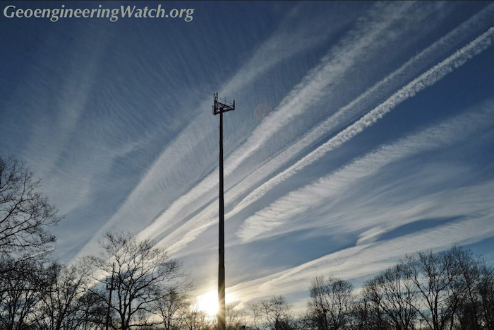
Central Pennsylvania. Photo credit: David Mace
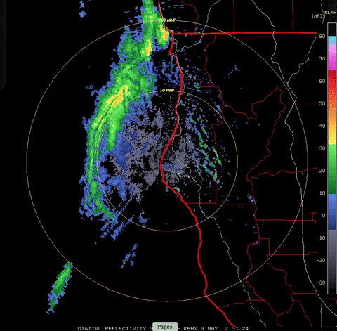
There is an already massive grid of climate intervention transmitters is constantly being expanded. The NEXRAD map below of the US is just an example of active RF / microwave transmitters. Various regions are active at various times depending on the agenda of the weather-makers.

Generally, the more atmospheric moisture there is in a particular region, the more active the transmitters are in that region.
The geoengineers can and are manipulating cloud formations and weather systems to a degree that is truly unimaginable and alarming. The satellite images below are further proof of this fact.
Weather system cloud configurations like the one shown above are historically unprecedented and completely unnatural.
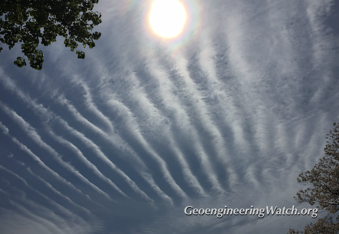
90 degree corners on weather systems (and the associated cloud formations) is not a natural phenomenon. Such profound anomalies are the result of extreme climate engineering processes which include RF / microwave transmissions.
Square clouds are one of the blatantly inarguable confirmations of climate engineering operations.
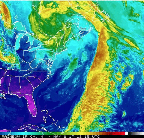
Massive flows of atmospheric moisture are being manipulated by the weather-makers. Radio frequency / microwave transmissions are a major factor in this manipulation. The animation below is a glaring case in point. Extreme flows of moisture are taking a very anomalous northward streaming trajectory. This atmospheric river is then directed back toward the west where it is drawn into a low pressure zone stationed right over Quebec, Canada, where catastrophic record flooding has just occurred. Now let’s consider the following points, the animation below was captured on May 8th, only one day after this headline from May 7th: “Canada Threatens To Play Hardball With Trump Over Lumber Tariffs” (this conflict has been escalating in recent weeks).
Quebec was not the only part of Canada to get pounded with record flooding following the well publicized conflict with the US, catastrophic flooding has also just occurred in other provinces across Canada.
Weather warfare is not theory, speculation, or conjecture, it has been a well documented historical fact for over a half century. Any and every form of climate manipulation / should and must be considered a form of weather warfare. Climate engineering / solar radiation management programs are now being pushed by the climate science community and governments around the globe as mitigation for Earth’s unraveling climate system. The power structure and mainstream media continue to try and pretend geoengineering / weather warfare has not already been going on for over 70 years (with catastrophic consequences). Legions of academicians continue to betray humanity and the web of life by their willful deception and denial of the ongoing climate engineering insanity. Geoengineering programs are not only decimating the planet’s life support systems, these operations are contaminating the entire surface of the planet and every breath we take (due to the highly toxic heavy metal and chemical fallout). The radio frequency / microwave transmissions pose even more dangers. We are all in a very real and very immediate fight for our lives and the life or our planet. We must all collectively prioritize our efforts toward the fight to expose and halt climate engineering / weather warfare, this is the great imperative of our time. The burden of this battle must be borne by us all, make your voice heard.
DW
May be freely reprinted, so long as the text is unaltered, all hyperlinks are left intact, and credit for the article is prominently given to GeoengineeringWatch.org and the article’s author with a hyperlink back to the original story.Read More
HAARP, A Short Summary Video
March 14, 2017 5 Comments
Share303Tweet+1SharePin1304 Shares
https://www.youtube.com/embed/KjkT9wy4AZ0Read More
Are Microwave Transmission Weapons Of Mass Destruction Being Used To Trigger Catastrophic Earthquakes?
November 15, 2016 83 Comments

Share3.4KTweet+1SharePin1023.5K Shares
Dane Wigington
geoengineeringwatch.org
Are unimaginably powerful microwave transmissions actively and aggressively being used as weapons of mass destruction? If all available evidence is examined, the logical conclusions are chilling. Understanding the full potential of the power that can be projected from the ionosphere heater installations (like HAARP) is difficult and complex. We all know and understand that microwave transmissions produced in our countertop ovens can heat a cup of water (or frozen TV dinners) at blinding speed. Unfortunately, most don’t know and thus have never even considered (let alone investigated) what massively powerful and interlinked microwave transmissions can do to the planet. When immensely powerful microwave transmissions are bounced off the atmosphere (facilitated by the atmospheric aerosol saturation) and directed back into the Earth’s strata (in a seismically sensitive location), the triggering of seismic activity becomes scientifically possible. The constant jet aircraft spraying of reflective and electrically conductive particles into the atmosphere (as part of the ongoing climate engineering/geoengineering assault) is a verifiable fact. Is New Zealand, yet again, the victim of microwave transmission super-weapons? There is a long list of shocking facts surrounding a number of recent catastrophic earthquakes. It is imperative to examine these facts without preconceptions or programmed denial. Let’s start with the month leading up to the extremely destructive 2010 earthquake in Haiti, MIT satellite monitoring detected a radical increase in ULF (ultra low frequency/microwave) radio transmissions over the quake epicenter.
Spacecraft Saw ULF Radio Emissions over Haiti before January Quake
A French satellite observed a dramatic increase in ultra low frequency radio waves over Haiti in the month before the M7.0 earthquake earlier this year.
DEMETER’s is an unusual mission. Its job is to monitor low frequency radio waves generated by earthquakes.
Today, a group of geoscientists release the data associated with the M 7.0 earthquake that struck Haiti in January. They say that DEMETER saw a clear increase in ultralow frequency radio waves being emitted from the Earth’s the crust in that region in the build up to the quake.
The anecdotal evidence of electromagnetic effects associated with earthquakes is legion. Various accounts link earthquakes with mysterious light and heating effects.
After the Haiti quake, the US military moved in and occupied the country. In addition, the long drawn-out Clinton Foundation reconstruction debacle began. The following year a deadly earthquake struck Christchurch, New Zealand. Many circumstances surrounding this disaster were also troubling. Did US officials know the earthquake was coming? Some excerpts from a report on the disaster are below.
Was the Christchurch earthquake a terrible natural disaster, or was it a terrible MAN MADE disaster?
9 members of US Congress were in Christchurch for a summit meeting on Feb 21 & 22 but left Christchurch 2.5 hours before the earthquake hit and relocated to Wellington even though the meeting was not due to finish until the evening of Feb 22nd.
The US Secretary of Homeland Security, Janet Napolitano, was supposed to be visiting Christchurch and speaking at the summit meeting on Feb 22, but on Feb 18 announced she was cancelling her visit 3. The Deputy Administrator of FEMA (US Federal Emergency Management Agency), Timothy Manning, just happened to be in Christchurch at the time with a US delegation.
All of the rest of the delegation left Christchurch shortly before the quake hit except for Mr Manning who stayed behind, and then after the quake hit he assisted with directing the emergency response. Exactly the same thing happened with FEMA delegates with the Haiti earthquake. In Haiti , the FEMA delegates just happened to be there at the time conducting training exercises for responding to major earthquakes.
Recent releases from Wikileaks resulted in the headline below:
Hillary Clinton Emails Show Advanced Warning of Christchurch Earthquake.
In the days before the catastrophic Japanese Earthquake (that occurred on March 11, 2011), world renowned research institution, MIT, yet again, noted extremely profound and anomalous atmospheric heating directly over the quake epicenter. MIT published the following report:
Atmosphere Above Japan Heated Rapidly Before M9 Earthquake
Infrared emissions above the epicenter increased dramatically in the days before the devastating earthquake in Japan, say scientists.
They say that before the M9 earthquake, the total electron content of the ionosphere increased dramatically over the epicentre, reaching a maximum three days before the quake struck.
At the same time, satellite observations showed a big increase in infrared emissions from above the epicentre, which peaked in the hours before the quake. In other words, the atmosphere was heating up.
Though the science community is desperately trying to link pre-quake atmospheric heating to some unknown phenomenon of an atmospheric coupling with the pressure buildup in the strata, is this a rational conclusion? The much more logical and straightforward conclusion is this, the atmospheric heating is being intentionally created by the global network of ionosphere heaters as immense microwave signals are bounced off of the atmosphere and back down into the planet. Unfortunately, the science community is not allowed to even consider this possibility, let alone talk about it. In the period preceding the decimating Japanese earthquake, US Japanese relations were very strained. The post-quake scenario of US/Japanese relations seemed to suddenly be unquestionable, was there a connection? Was the catastrophic quake just a natural event? Or an engineered warning to Japan?
On the 13th of November, 2016, another catastrophic earthquake struck near Christchurch, New Zealand. The list of troubling questions surrounding this earthquake is long and growing. Below are some quotes from seismologist Anna Kaiser (who is investigating the latest New Zealand earthquake activity):
We don’t know what we are dealing with right now but it may be … it involves potentially more than one fault … we need to figure out what was going on before and after the 7.5 magnitude quake…
Kaiser went on to say this:
We’re working very hard … this is looking quite complex. The epicenter was possibly just south of the Hope fault, but it did look like “something else was going on.
The seismologist statements are only the beginning, there are many more concerning factors surrounding the latest New Zealand Earthquake that should be considered.
In spite of the unfolding US election circumstances, in the days before the latest New Zealand quake John Kerry first went to Christchurch, and then on to McMurdo Station, Antarctica. The stated purpose of Kerry’s visit was to examine the effects of global warming and the record low sea ice, but this trip at this time was criticized by some.
US Secretary of State John Kerry is scheduled to head back to New Zealand after checking out summer in Antarctica.
He’s been criticized for heading to such a remote place while the US election riveted the world
He tweeted a photograph of himself boarding C-17 cargo plane in Christchurch saying “headed to Antarctica to see firsthand some of the drastic effects of climate change”.
In Antarctica he was scheduled to meet with scientists and researchers at McMurdo Station, the largest research station of the US Antarctic programme, as well as visit surrounding areas on Ross Island, and the US Government’s Amundsen-Scott South Pole Station.
He is the first secretary of state and the most senior US government official to ever travel to Antarctica.
He is hosted by the US National Science Foundation, which manages the US Antarctic program me.

In fact Antarctica has just broken a new climate record, with record low winter sea ice. After a peak of 18.5 million square kilometers in late August, sea ice began retreating about a month ahead of schedule and has been setting daily low records through most of September. Though Antarctic sea ice (and global sea ice) are at record shattering low levels, why else might John Kerry go to McMurdo Station at this exact window of time? Could the ionosphere heater (microwave transmission) facility that is constructed at McMurdo be a factor?
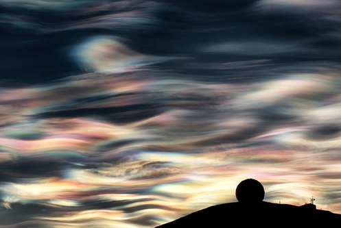
Noctilucent clouds in the skies above Antarctica are an ominous harbinger of the atmospheric damage that is occurring there.
Many are under the belief that HAARP, now labeled IRI, no longer exists Operationally due to the Gakona, AK spin. One must understand that these Frequency Generators are Globally Ubiquitous. There are so many that are of dissimilar designs, and go by different acronyms, it is not seen as functionally one and the same. In the case of McMurdo’s Radome and all of the Radar equipment there; Raytheon has had the contracts beginning to end. The National Science Foundation and Raytheon Polar Services Company are housed in the same building. For years the station has grown. It can house 1258 personnel and an average of 200 winter over.
Raytheon is one of the largest private “defense contractors” on the planet, this corporation is also the holder of numerous climate engineering patents including some that relate directly to ionosphere heaters. The power structure is likely microwaving the skies for a multitude of reasons, none of those reasons are in the interest of the common good.
Shocking atmospheric flashing lights were filmed in the skies above New Zealand as the massive Earthquake was occurring.
Kerry returned to Christchurch from Antarctica, and then promptly (and conveniently) departed only hours before the catastrophic earthquake struck.
The statement below is from CBS news.
Sec. John Kerry had left the country before it struck, and just landed in Singapore on his way to Oman when news of the quake was reported.
Is it just a coincidence that US officials always seem to safely depart quake impact zones just prior to the event?
Then there is this headline to consider:
World’s Biggest Seismic Testing “Blast” Ship – Amazon Warrior – Parked on top of New Zealand Fault Line
Is this just a coincidence?
Another point of interest, New Zealanders protested against US Oil exploration continued right up to the day before the quake. Then there was the conflict in New Zealand over the visit of a US warship, this story was covered the day before the quake hit.
The New Zealand Prime Minister’s apparent apprehension about the US election results just days prior to the quake are also of interest.
Finally, could known massive oil deposits just off the New Zealand coast also be a part of the equation?
Microwave transmission signals/rings near Antarctica are clearly visible in the satellite composite image shown below.
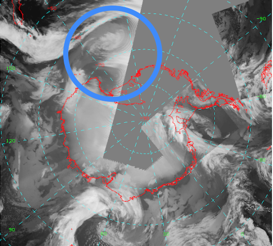
The regions of New Zealand near the epicenter have been constantly assaulted with aerosols spraying and microwave transmissions.
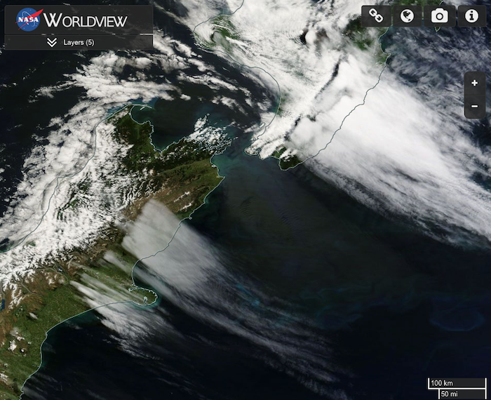
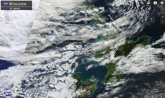
The uniform ribbing of aerosolized cloud cover is a clear indication of microwave transmission exposure. Though some “official” sources try to explain this type of cloud pattern as being a result of the underlying land topography, this explanation is patently false. The same patterns are now regularly seen over oceans as well as land as is shown in the satellite photo below that was taken of New Zealand directly over the quake region.
The image below bears testimony to what the global power structure does to those that try to get in the way of their agendas and operations. This photo is of the bridge of the Greenpeace ship “The Rainbow Warrior”. It was bombed and sunk by the French Secret Service in order to prevent the ship and its crew from witnessing ongoing illegal and unimaginably destructive nuclear detonations.
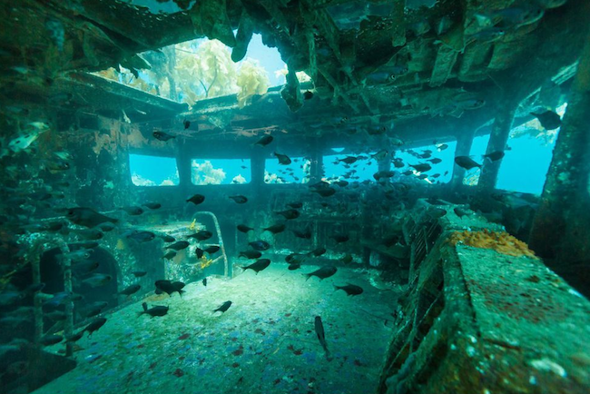
Over 2 decades ago I dove alone on the wreck of the Rainbow Warrior, as it laid on the seafloor off the coast of New Zealand. I swam through the area shown above, around the ship, and examined the gapping bomb blast hole in the hull of the once noble vessel. I hovered over the wreck and contemplated the tyranny of those who rule the world. We are all at a crossroads, and the horizon is darkening rapidly. The power structure wields weapons of unimaginable destruction, they can only do so because of the order-followers that carry out their insanity. As the saying goes, “we have seen the enemy, and they are us”. It is up to us, the people, all of us, to refuse any further participation in the insanity. It is up to us to fully investigate and fully face the whole truth. It is up to us to prioritize the fight for the greater good because we owe that debt to our children, to the planet, and to the whole. Make your voice heard, while you can, while it can still matter.
DW


Pingback: WEATHER WARFARE: Heat Waves & HAARP – By Joseph P. Farrell Ph.D — RIELPOLITIK – Kensho Homestead
I think Amazing Polly’s thoughts are correct for why they burned down Lytton, BC. https://www.bitchute.com/video/dbZwKX5ERuFz/